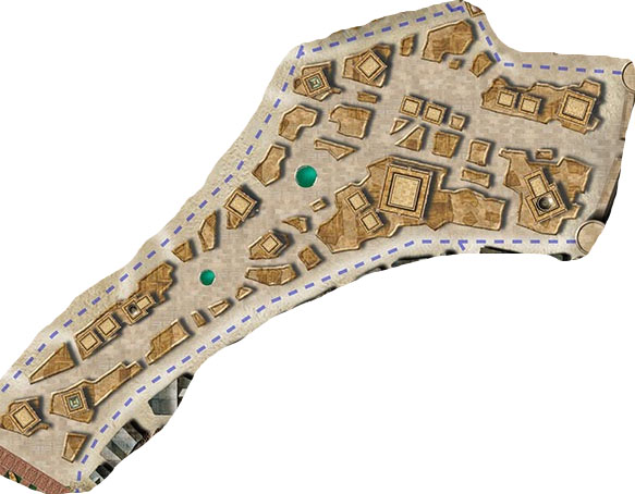
A common form of mapping for RPG cities is the block map. For example, here’s the city of Kintargo from the Hell’s Rebels adventure path:
A common mistake when looking at such a map is to interpret each individual outline as being a single building. For example, when I posted a behind-the-scenes peek at how I developed the map for the city of Anyoc years ago, a number of people told me I’d screwed up by leaving too much space between the buildings. Except the map didn’t actually depict any individual buildings: Each outline was a separate block, made up of several different buildings.
When people look at a block map and interpret it as depicting individual buildings, how far off is their vision of the city?
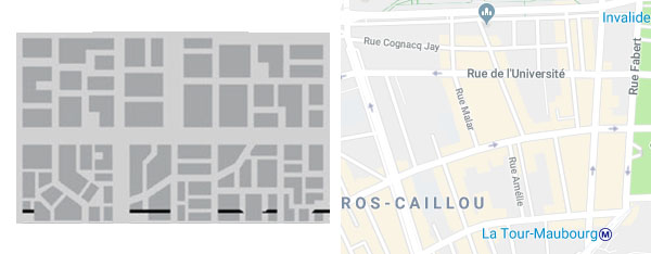
Well, we can actually see this exemplified in a few cases where artists have (in my opinion) misinterpreted block maps. Blades in the Dark, for example, has a block map for the city of Duskwall. Below you can see a sample of that block map (on the left) next to a block map of a section of Paris (on the right).
If it was not self-evident, the interpretation of the Duskwall map as a block map is supported by this description of the city from the rulebook:
The city is densely packed inside the ring of immense lightning towers that protect it from the murderous ghosts of the blighted deathlands beyond. Every square foot is covered in human construction of some kind — piled one atop another with looming towers, sprawling manors, and stacked row houses; dissected by canals and narrow twisting alleys; connected by a spiderweb of roads, bridges, and elevated walkways.
You can see that if you interpret Duskwall’s map as detailing individual buildings, the layout of the city actually becomes far more organized and well-regulated than seems intended by the text. This is, in fact, a common problem when GMs misinterpret block maps: Their vision of the city, and the resulting descriptions are heavily simplified.
For example, when Ryan Dunleavy decided to develop a large version of the Duskwall map, he interpreted each block on the map as being an individual building (or, occasionally, two). Compare the resulting illustration of a single block in Duskwall (on the left) to what a single block in Paris (on the right) actually looks like:
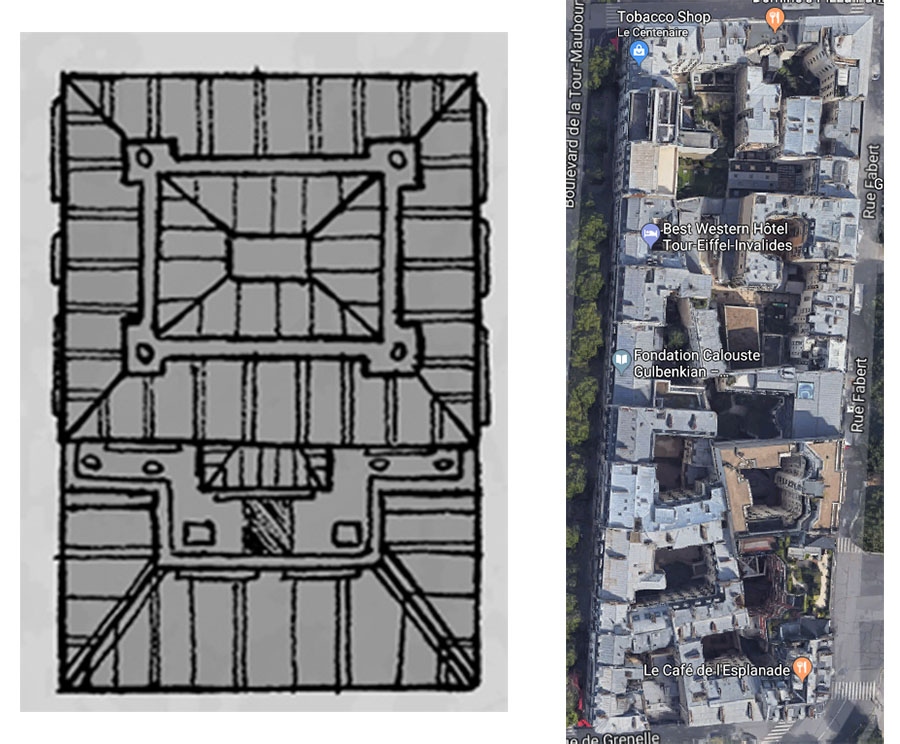
(Please don’t interpret this as some sort of massive indictment of the artist here. Ryan Dunleavy’s cartography is gorgeous, and I recommend backing his Patreon for more of it.)
You can see another example of this with Green Ronin’s Freeport. When first revealed to the world in 2000’s Death in Freeport module, the city was depicted using a rough block map:
In 2002, for the original City of Freeport, this was redone with most of the blocks being represented as individual buildings:
The map was redone again for The Pirate’s Guide to Freeport, this time reinterpreting the original outlines as a block map:
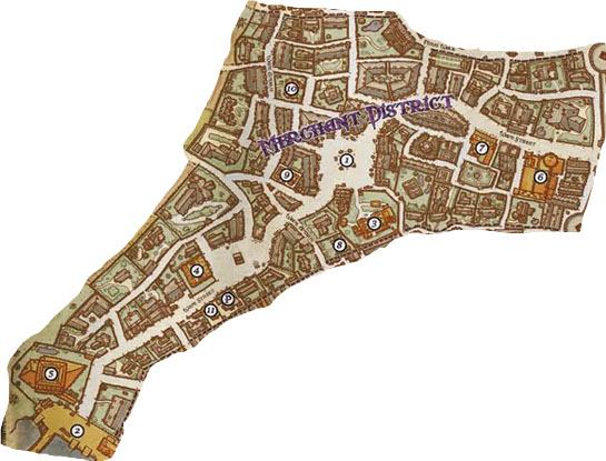
I pull out this example primarily to point out that sometimes a block map outline IS, in fact, a single building. Because some buildings are really big. Or, in other cases, they might represent walled estates, as shown here with the estates along the western edge of the map.
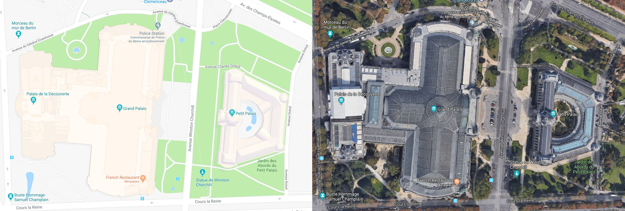
And here’s a real world example of this from Paris with both the Grand Palais and the Petit Palais:
(click for larger size)
The north-south cross section of the Grand Palais is fairly comparable to the Parisian block shown above.
CONCLUSION
My point with all this basically boils down to don’t mistake the map for the territory. One of the great advantages of the block map approach to city mapping is that it leaves so much to the imagination, allowing both you and your players to lay in immense amounts of fractal complexity onto a simple geometric shape.
(Which is not to say that block maps are the be-all or end-all of utility at the gaming table. You can take my copy of Ed Bourelle’s Ptolus map when you pry it from my cold, dead hands.)
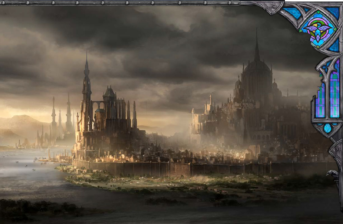
And when you miss that opportunity — when your mental image of the block map reduces each geometric shape to a single building — you’re robbing the city of its grandeur, its complexity, and its flexibility.
Take a moment to go back and look at the map of Kintargo, for example. Imagine what that city would look like if each block were, in fact, a single building. What you’ll probably end up with is a modest city still possessed of some good degree of size. But what you should actually end up with in your mind’s eye is this:


In the Kintargo map, each block is shaded in such a way that it looks like a rooftop. This may contribute to the confusion.
I’ve consistently found the Paizo city maps (Korvosa, Magnimar) completely unuseable; this Hell’s Rebels one looks a bit better, but something like the actual Paris street map would be better again.
I do wish mappers would look at actual medieval (& Roman) city plans and see how the buildings & streets fit together. Artists based in Europe can be ok since they are often surrounded by basically medieval street plans, but New World artists often create stuff that looks like suburban Chicago.
There’s something wrong with the Kintargo map. It’s not only, as Doodpants says, that the blocks are shaded like they’re rooftops.
The road network seems somehow off. Can’t really put my finger on it. There are now dead ends, like on the google map of Paris you posted.
And there’s features I can’t interpreted, if the map depicts city blocks rather than houses. There’s grey spaces between ‘blocks’ and roads, like in the bracket ([) shaped building between J1 and J3. Or under J5. What is that? It’s not part of the road, since roads are clearly white. But there’s presumably no buildings there, because it’s not part of the city block. Is it a market square? But why the distinction between roads and squares, surely both are cobbled by the same stones (or what-ever road surface is used)?
A final problem with the Kintargo map is the parks. It’s a strange thing to find so many, and so large, parks in what’s presumably a medieval-ish city. But fine, I can take that. Even though most of them doesn’t appear to be walled in and two of them are larger than a dozen city blocks. But the dark green splotches in the light green parks – are they individual trees? I can’t convince my eyes that they’re anything else, but man, that does not grok with it being a city block map.
Nope, I want my maps to be like this https://www.almedalsbiblioteket.se/verksamheter/1125-bibl/version/default/part/AttachmentData/data/fegraeus_1889.jpg 1900-century map of medieval Visby. There, I can get a sense for the size of the city and imagine all sorts of interesting things existing.
Or, of course, just use a Google map of Paris or Budapest or Rheims or Innsbruck as your map and you can get the best of both worlds. After all, how farmilliar are your or your players with the old city of Lucerne?
I agree with all the points you raise about mapping cities, but the art style of the Kintargo map for Hell’s Rebels points the reader towards the conclusion that they are individual buildings. So, S’mon’s referencing the artist’s experience of maps is also critically important. This can be fixed with some research, either by exploring the older spaces (if you are lucky enough to have ready access) or jumping online (See links of maps below);
https://www.davidrumsey.com
https://www.oldmapsonline.org/
However, as they say, “the Map is not the Territory”. As direct experience of these ancient cities becomes important to gather the feel of the environment. Thankfully, Google’s Streetview can provide some of that visual feel of the architecture. The narrow alleyways and the push of the buildings out into the street as claim more space. The mix of a hundred layers of history from posters, grunge, graffiti, and life.
Almost any city can provide a reference if you can translate it through time. Even modern cities, which are more planned than evolved, have older corners where a building has had many businesses set up within its four walls.
Blymurkla’s point about the problem with parks maybe resolved if they become walled areas for the dead (EG the graveyards in T4 or O6), places the rich (EG Aria Park J4), or filled with tent cities for the poor. As a GM it comes down to how we populate our city with people & places. These are not ideal solutions because as I stated at the start the artist’s map points us in a particular direction.
Kevin Lynches method for creating mental maps (see The Image of the City 1960) could also be a looser approach, defining some areas but leaving a great deal to the imagination.