City Supplement 3: Anyoc was essentially a completed product when Dream Machine Productions went on hiatus. The only thing we were waiting for was the map. In fact, it was my intention to release it as our last product before the hiatus. But, unfortunately, the cartographer we had working on the project never completed it. Since we were shifting into a hiatus state in any case, I shelved the project.
As we started gearing up to come out of hiatus, however, I started working on the map myself. Here’s what the original sketch map that I drew way back in 2001 looked like:

Basically, there was little laid out except for the gross geography and spatial relationships of the city. However, I know that one of the things I love about a good city supplement is the map: As a handout, there are few things more satisfying than being able to slap down a really slick-looking map for the players to look at. And I’ve found that there are few things that can get my creative juices flowing like a good map: Imagine yourself standing on those streets and looking at those buildings. What does that colorful roof really look like? What lies beyond that door or hidden around that corner?
I knew that executing a city map to the standards that I would demand out of a product would be tough. I had previously designed the map for Aerie (City Supplement 2), but that was a very different type of project: Aerie had been carved out of solid rock according to a relatively rigid plan. For Anyoc, I felt it was important to capture the more natural and organic curves of a living city.
So I started researching.
SURVEYING THE FIELD
The first part of this research was a matter of “surveying the field”. I went to my shelves and pulled down a wide representative sampling of city maps from other roleplaying supplements. Notable examples include:
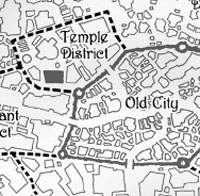
As you can see, there have been many different ways of handling the cartography for fantasy cities. Based on my recent experience with Ptolus, among other things, I knew how incredibly useful it could be to have every street and every building detailed on the map. As a player, I love the ability to say “I’m going to X by heading down this street right here”. And as a DM I love being able to say, “Okay, the House of Violet Gold is this building right here.”
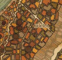
With those goals in mind, I pushed aside the very generic style of maps like the one seen in the Freeport sample above. These types of maps are a bit more graphically detailed than my sketch on graph paper, but the detail is largely illusory — none of those blobs actually represent anything meaningfully concrete.
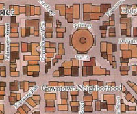
I also stepped away from the style of map seen in the Minas Tirith sample above: These maps resemble the kind of cartographical lot maps created by city surveyors and the like.
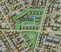
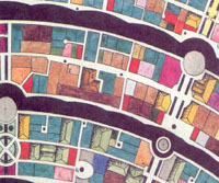
While I couldn’t create the type of detailed, individual buildings created by Ed Bourelle for Ptolus (unless I wanted to charge a lot more for the finished product than I was planning to), I felt that a “roof outline” style (such as those used in the Raven’s Bluff and Sharn examples above) represented the best compromise. Here’s the style I ended up with:

With a style in hand, it was time to start laying out the streets. But before I could do that, I had to finish my research.


