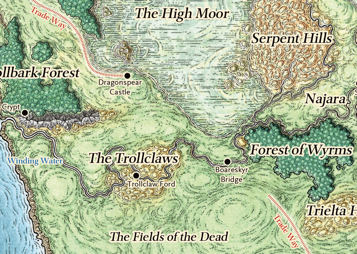
So here’s a thing about the Forgotten Realms that’s bugged me off-and-on for thirty years: You see that gap in the Trade Way?
It shouldn’t exist.
According to traditional Faerunian lore, the Trade Way runs from Luskan in the north all the way to (depending on time period/edition) Amn or Tethyr or Calimport in the south. There shouldn’t be a gap in it.
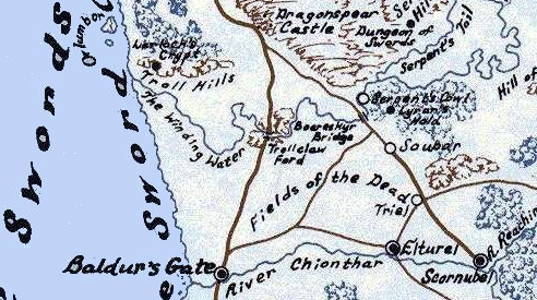
It turns out that the origin of this gap is from this map in the 1st Edition Forgotten Realms Campaign Setting boxed set:
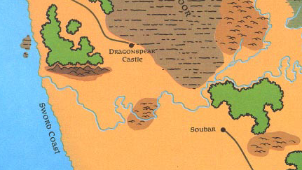
For a long time I assumed that this passage from the campaign setting was responsible for the gap:
In recent years, some evil agent allied with he orcs, trolls, and bugbears of the High Moor succeeded in opening a gate to the Nine Hells within [Dragonspear Castle]. Strengthened by a growing army of devilkind, the combined forces of the High Moors tribes devastated the area from The Way Inn to Boarskyr Bridge, such that today that part of the Trade Way is not considered safe territory.
Given the absence of the road from the map, I thought “not considered safe” and “devastated” might mean that the Trade Way had actually been destroyed here, severing the easiest trade route between the northern and southern reaches of the Sword Coast.
This was not actually the case. In fact, an army had marched against the devils of Dragonspear Castle, sacked it, and established regular armed patrols out of the Way Inn.
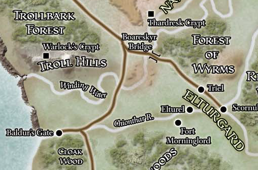
Before we move on, however, let’s talk about what happens between Scornubel and Baldur’s Gate:
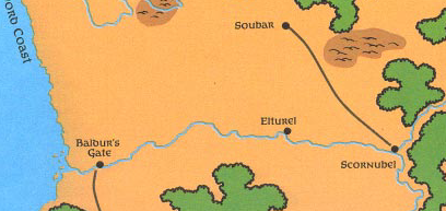
For an even longer time (based on the map), I assumed that the Trade Way actually was interrupted here: Trade would come down the road to Scornubel and then take the Chionthar River to Baldur’s Gate before continuing south.
This also turns out not to be the case: The Trade Way has always entered Baldur’s Gate via the city’s north gate, which would imply that there must be a road which runs from Scornubel to Baldur’s Gate (and various snippets of text support this).
But here’s the odd thing: Elturel is never described as being on the Trade Way, despite the fact that logically a road from Scornubel to Baldur’s Gate would pass right through the city. In fact, Elturel is explicitly NOT on the Trade Way; instead a road heads northeast from the city and “meets the Trade Way” at the village of Triel.
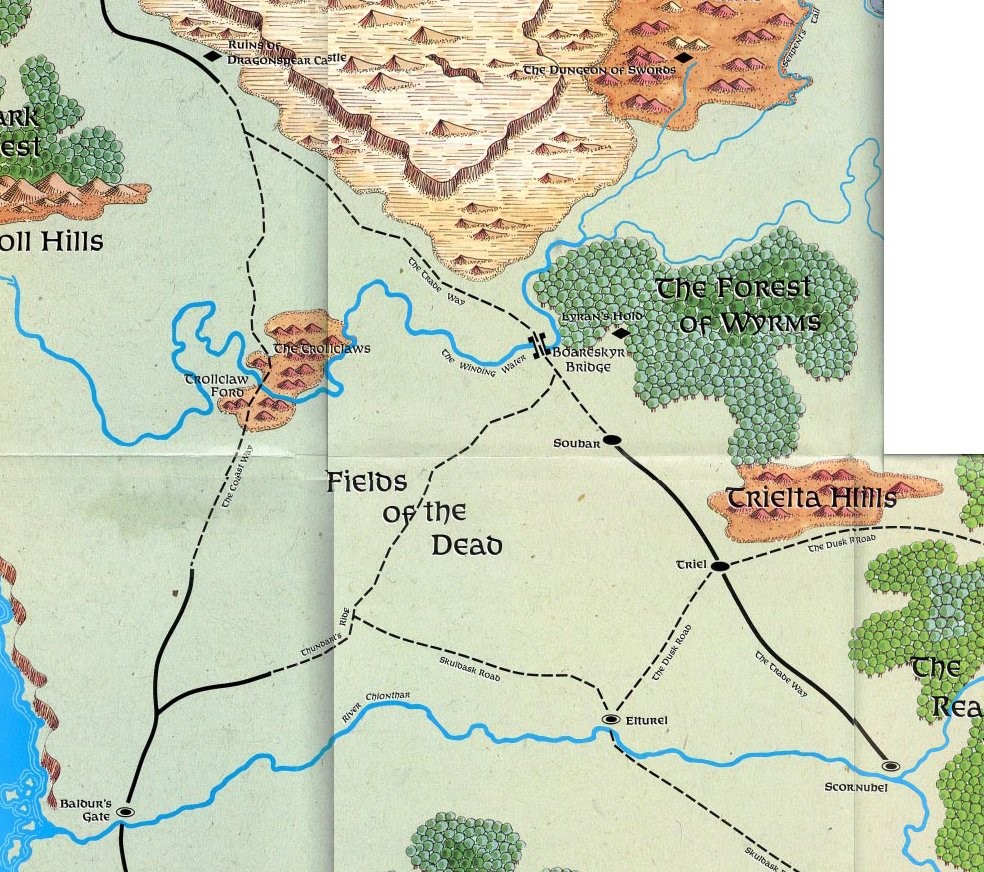
Now, more detailed maps DID exist:
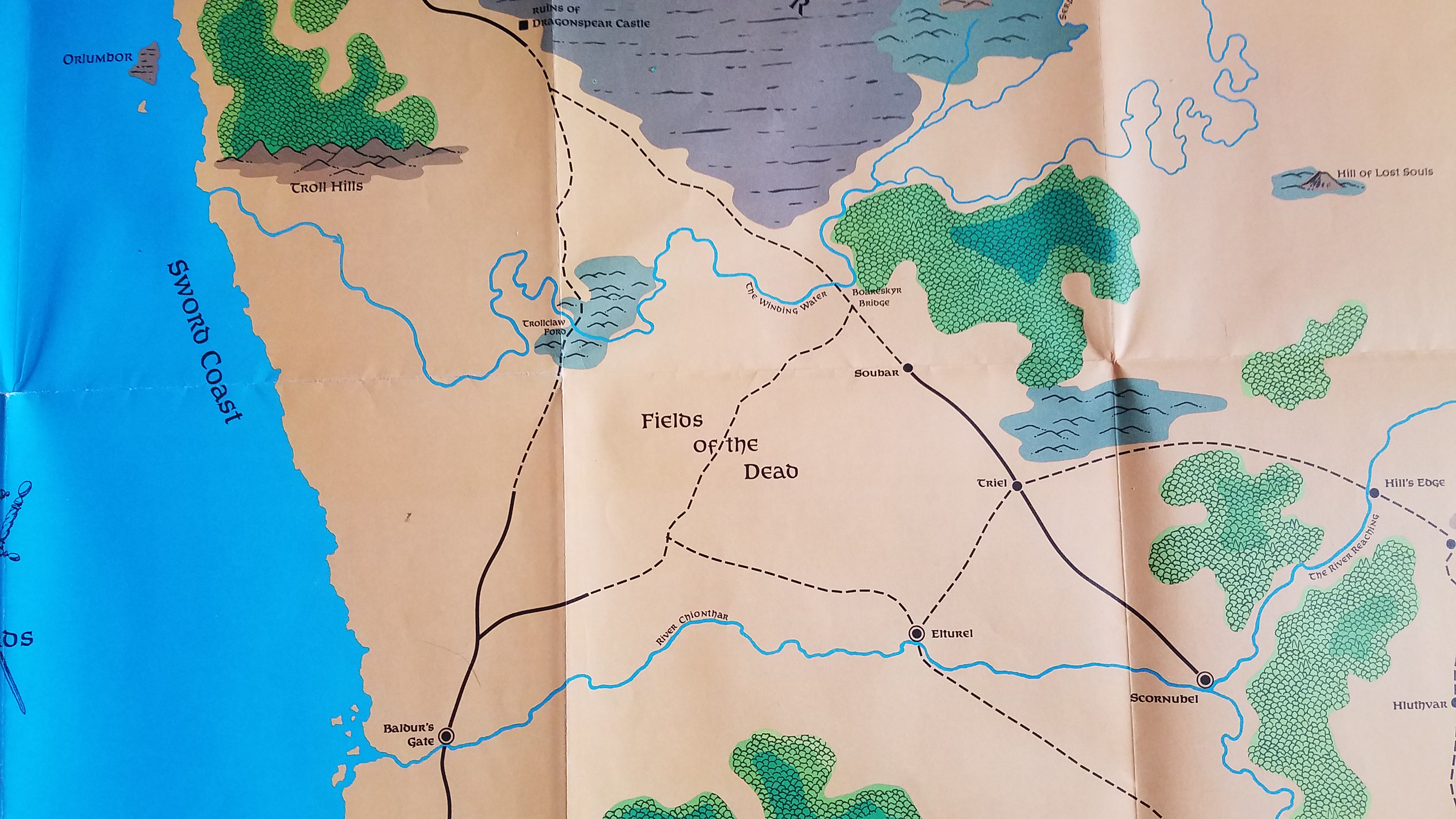
(Thanks to @roboros for pointing this one out to me.)
You can see from this map that the “gap” is actually a section of less-developed road along the Trade Way. There’s still no road between Elturel and Scornubel, however, so we still don’t know how the Trade Way gets from Scornubel to Baldur’s Gate.
The next map was, as far as I can tell, produced for the Forgotten Realms Atlas (1990):
The big difference here is that the road leading directly from Dragonspear Castle to Baldur’s Gate has been upgraded to a major road. Which also prompts a new question: Why isn’t THIS road used as the Trade Way?
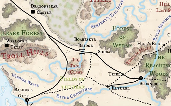
We do have another source here: Ed Greenwood’s original map.
These were apparently displayed at Gamehole Con in 2019 and you can find photos of them here.
The details are a little hard to see, but we can generally make out that the maps we’ve seen so far largely echo Greenwood’s original cartography. (The only quibble I’d have is that I’m fairly certain the intention is for two roads to leave Boareskyr Bridge to the south; not for one road to run several dozen miles south before splitting.) The big thing to note here is that the lack of a road between Elturel and Scornubel is NOT a production error; Greenwood didn’t have it on his original map.
This brings us to 2nd Edition, which largely follows what we’ve seen so far but notably labels the road to Baldur’s Gate as the “Coast Way”:
(We’ll come back to this.)
The Realms map was then completely redone for 3rd Edition:
It turns out this map is very controversial among Realms experts. While adding considerable detail, it notably introduces a number of errors. (For example, in this section you can see how the road which is supposed to cross the Winding Water at the Troll Claw Ford is depicted here as missing the Troll Claws entirely.)
As far as the Trade Way is concerned, it’s a mixed bag. The decision has been made to upgrade its entire length to a major road, and it’s also added the road between Scornubel and Elturel that we’ve hypothesized must exist. But the route still isn’t particularly clear: West of Elturel, the road now cuts far to the northwest (almost all the way to the Troll Claws), and this section hasn’t been upgraded to a major road like the rest of the Trade Way.
Let’s move onto 4th Edition:
This map is… interesting. It’s obviously a regression in terms of detail, but there are also a number of glaring inaccuracies. (The road crossing the river far to the east of Baldur’s Gate instead of passing through Baldur’s Gate is probably the most notable for our purposes.)
The other notable thing here, however, is that the writers of 4th Edition also clearly wondered why the Trade Way would go all the way easy to Scornubel if there was a road heading straight to Baldur’s Gate.
Their solution was simple: It doesn’t. In 4th Edition, the Trade Way no longer goes to Scornubel. The write-up of Scornubel never mentions the Trade Way and the description of the Trade Way itself makes it fairly explicit:
Over the centuries, numerous separate caravan paths coalesced into a well-traveled route along the western edge of Faerun called the Trade Way. Regular traffic once extended from Luskan to Calimport, but has been truncated since the Spellplague. It now runs from Waterdeep to the southern edges of Tethyr. Parallel to but usually some distance from the coast, the route moves farthest east just north of Baldur’s Gate, where Elturgard paladins guard the crossing at the Winding Water River. Few, if any, of the lands through which the Trade Way passes are completely safe, and caravan guards are in constant demand.
(Somewhat incoherently, however, the same campaign guide still asserts that the Trade Way crosses Boareskyr Bridge. Which, of course, it wouldn’t do if it’s following the road to Baldur’s Gate.)
This brings us back to 5th Edition’s version of the Realms, with the original version of the gap we looked at to begin with. My understanding is that 5th Edition’s cartography went back to the original 1st Edition maps in order to sort of “get back to basics.” Unfortunately, the result was to also reintroduce a lot of errors and shortcomings from those original maps (including the gap in the Trade Way).
THE TRUTH OF THE TRADE WAYS
When I started this write-up, my original intention was to basically just say, “Hey! Look at the gap!”
But it turns out there’s a deep lore here.
If you do a close reading of the 1st Edition boxed set (which I, in fact, just did while fact-checking all this), you’ll discover that the entire idea of there being a single “Trade Way” is an illusion.
There was a Trade Way from Amn to Waterdeep. For example, Baldur’s Gate was “situated on the northern shore of the river, astride the Trade Way from Amn to Waterdeep.”
But there was another Trade Way, from Waterdeep to Iriaebor:
![[Elturel] has been seeking ways to unseat Scornubel as the major trading town on the Trade Way between Waterdeep and Iriaebor.](https://www.thealexandrian.net/images/20200417i.png)
And it is this second Trade Way that goes to Scornubel!
The reason there’s no road from Scornubel to Baldur’s Gate (and why Elturel is explicitly not on the Trade Way) is because there ISN’T a Trade Way between Baldur’s Gate and Scornubel.
They’re two different Trade Ways. (In fact, my suspicion would be that there were originally many more Trade Ways. These were just the ones that got particular mention in the first boxed set.)
In the 2nd Edition boxed set, the addition of the “Coast Way” was actually an attempt to make the difference between the two different routes clear. In fact, this boxed set never refers to Baldur’s Gate as being on the Trade Way. Instead, “it is situated on the northern shore of the river, astride the Coast Way from Amn to Waterdeep.”
But I suspect that due to all the prominent references to Baldur’s Gate “being on the Trade Way” and “the Trade Way follows the coast” that already existed, this distinction became confused. In short order, the Coast Way was effectively just another name for the Trade Way, and shortly thereafter it would be explicitly stated as being such, reintroducing the confusion.
Of course, this means that there’s actually ANOTHER gap in the Trade Way, this one between Scornubel and Iriaebor:
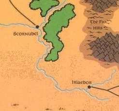
Unfortunately, there doesn’t seem to be any clear solution to this. No maps of the Realms appear to depict roads heading south from Scornubel.
Nevertheless, the original intention is fairly clear: The Trade Way from Waterdeep split north of the Winding Water, heading to Amn (gateway to the South) and Iriaebor (gateway to the Inner Sea).
LOST IRIAEBOR
I think the real victim here is Iriaebor.
If the cartography accurately depicted the Trade Way running all the way through to the City of a Thousand Spires, Iriaebor wouldn’t just be one of a number of cities crammed in around the Far Hills. Instead, it would very clearly be the Constantinople-like lynchpin between the Sword Coast and the Dalelands.
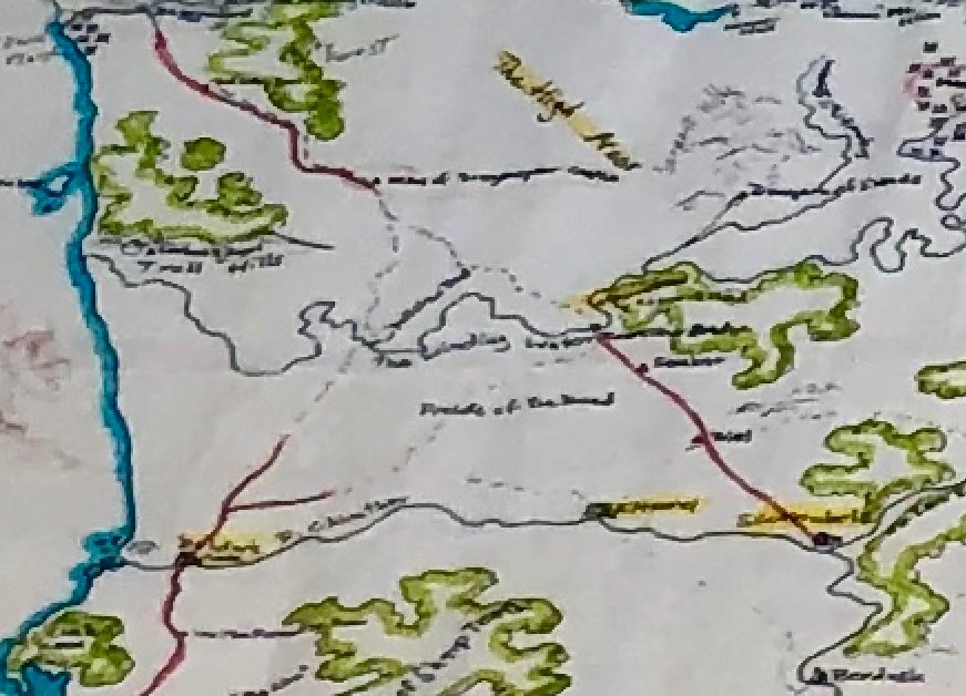
Let me show you what I mean by sketching in the “missing” roads on the 1st Edition map (imagining the Trade Way punching through the Reaching Wood southeast of Scornubel for lack of a better option):
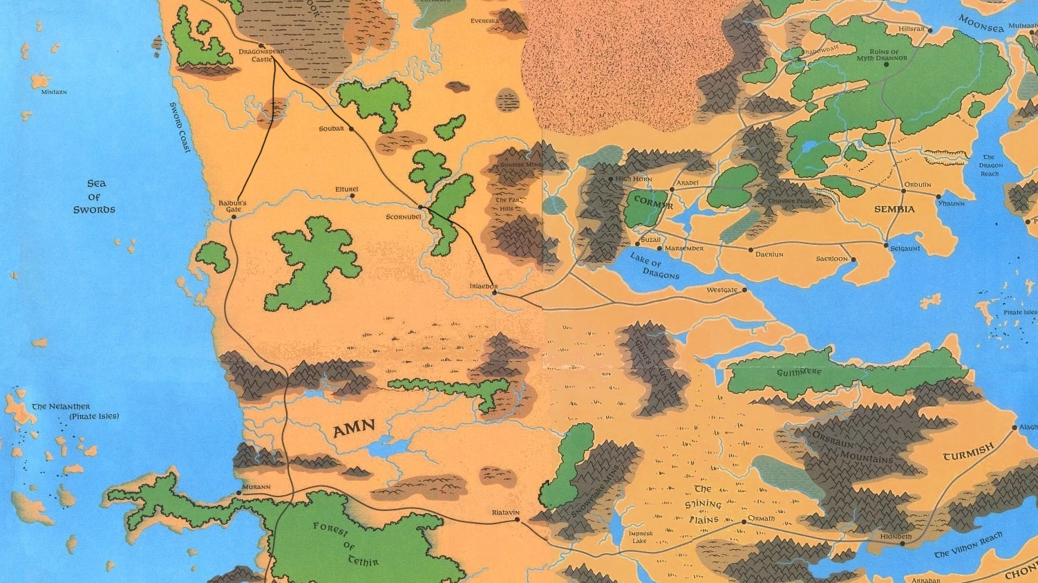
(click for larger image)
The importance of Iriaebor immediately leaps out. It’s obvious at a glance that it’s the only game in town for east-west travel for hundreds or thousands of miles in either direction. Every campaign in the Dalelands that wanted to go to Waterdeep would have gone through Iriaebor, sitting almost directly in the middle of the map with every road north of Amn leading straight to it.
I find it quite plausible to imagine that more DMs, designers, and novelists would have been drawn to the city. In the Cyclopedia of the Realms, page 54 might have become well-thumbed:
The Ruler of Iriaebor is Bron, who was an adventurer catapulted into the position in the heat of a shooting war between merchant families. Bron feels Iriaebor has the resources to become another Waterdeep…
Let’s spend a little moment dreaming of Bron’s dream together.


“Let’s spend a little moment dreaming of Bron’s dream together.” Right in the feels haha. What’s the source for the map that roboros pointed you?
Also the 1e boxed set. It appears this detail map wasn’t included in the PDF WotC sold and @roboros let me know that I should have gone downstairs to check my physical copy.
(Not sure if the current WotC PDF has been updated. I purchased mine in the pre-4E era.)
Justin Alexander for President of D&D
It also seems that logically if that river to the south ends where it does, then the road leading to the east from Iriaedor should also split south and head around the east edge of those mountains to Riatavin.
Thank you so much for this! This section of The Trade Way has bothered me for a while, and the conflicting maps don’t help. I ran a caravan-based game for students a while back, where the whole goal was to take a caravan from Calimshan to Neverwinter, and oh the headaches I had trying to cross reference different versions of maps. That still gives me headaches. I wish there was one truly excellent, definitive map…
I also want to point out I find it totally plausible (in fact maybe even more believable) that there would be gaps and divergent branches of “The Trade Way.” That could easily become a commonly used term for the concept, when in reality the actual road is a little more complicated.
I actually love Greenwood’s original map (thank you!) where the section north of Baldur’s Gate gets… complicated. There are options: go up the river, take the sketchy, dangerous route through the Fields of Dead and the Troll Claws, or just catch a ship for this next section up to Waterdeep, but none of them are perfect, and a merchant caravan has some difficult choices to make here. I’m fine with all that!
Except… why on earth does “The Trade Way” go to Scornubel? That’s the part that never made sense to me!
The piece you’ve added, which I’m deeply grateful for, is the insight that *that* Trade Way actually goes on to Iriaebor, and becomes the only overland route connecting two major parts of the world. That’s so cool!
That really helps me understand this region, and for my purposes, I’ll probably just keep the idea that the road south from Scornubel is not well traveled or in great condition. But it’s still an important route.
I bet Ed Greenwood was aware that historical river transport costs were a fraction of costs by road, and intended that the Trade Way took to boats between Scornubel and Iriaebor.
Is there any mentions of travel by river barge?
So, we will have to send out a small expedition to find out if the maps are wrong and a route DO exist!?
Cool!
“Regular traffic once extended from Luskan to Calimport, but has been truncated since the Spellplague. It now runs from Waterdeep to the southern edges of Tethyr. Parallel to but usually some distance from the coast, the route moves farthest east just north of Baldur’s Gate, where Elturgard paladins guard the crossing at the Winding Water River.”
I can’t figure out how you got “the Trade Way no longer goes to Scornubel” from this. The map shows the road branching to the southwest (towards Baldur’s Gate) and the southeast (towards Scornubel), and the eastern branch crosses the Boarskyr Bridge and passes through Elturgard — exactly as the text describes.
If the farthest east it gets is the crossing of the Winding Water River, then it doesn’t go to Scornubel (which is even further east).
@Justin, not sure who you were talking to, but I said river transport from Scornubel to *Iriaebor*, not Baldur’s Gate. Unless I’m really missing something, nothing contradicts that. In fact, if this stretch is intended to be primarily riverine, the passage about Elturel and Lord Dhelt wanting to unseat Scornubel makes more sense. Trading a longer stretch on the river for a shorter overland route is plausible; while if transport is all by road then any road through Elturel is almost inevitably going to be longer than an alternative through Scornubel.
It really looks like that must have been the original intention, and it’s a shame that whoever wrote the Iriaebor entries didn’t realize it.
The Trade Way isn’t a physical piece of infrastructure- it’s the name of a route that meanders over time. Just like Earth equivalents like The Silk Road, the Oregon Trail, the California Highway, the Amber Road and the Via Maris, there is no exact route – just a number of geographic choke points and recognised stopping-off points that was and wane in importance with the changing fortunes of economics and politics.
We are conditioned as thinking of a road as a definitive piece of macadam because cars need petrol. Horses and oxen don’t and the best way to keep them fuelled is NOT to follow the people who went before you eating the grass. On grasslands, where geography is not an issue, the Trade Way can be dozens, even hundreds of miles wide.
I’d say the gap makes perfect sense because between Baldur’s Gate and the High Moor there’s only some farmland and little reason to run caravans when you could sail along the coast. But then, the same could be said for many overland routes in the Realms.
Somewhat related: I’ve been fleshing out the Dessarin Valley for a hexcrawl campaign and quickly stumbled upon the question: why does the Long Road exist? The Dessarin carries trade from Waterdeep all the way to Yartar, from where you can sail all the way to Silverymoon. The river Mirar seems to be the only economic connection Mirabar needs. As Colin says in comment #6: river travel is superior to the best maintained roads. None of the settlements in the region are large enough to generate that much traffic, and the area isn’t safe. My conclusion: trade roads exists so adventurers can guard caravans, and have wilderness encounters, not for economic reasons 🙂
I love this passion, Justin Alexander. Thank you from Italy!
Why you don’t ask to him on Twitter? https://mobile.twitter.com/theedverse
Maybe we can have a reponse!
Another reason why I wish WotC had built a new world for 5e.
A thought regarding the gap between Scornubel and Iriaebor with an aim to at least solve the issue in 5th edition: The Reaching Woods have been banned! As written in the Forgotten Realms Campaign Guide pg. 125: “The High Observer, declaring that goblins are vicious creatures and that gnolls serve demons, ordered the forest barricaded. No one can enter or leave, on pain of death.” This explains why the Trade Road (if it existed at all) no longer is present between the two cities, as who would want to risk their life for this, instead, merchants would either travel via the river by Berdusk, or via Triel and the Dusk Road.
I can answer some of the questions in the comments here. There are barge tow trails along most of the Chionthar. Between Scornubel and Berdusk they’re located on the south bank and between Berdusk and Iriaebor they’re located on the north bank. The latter route is names “Rupert’s Way”. There are sources mentioning the transporting of wares up and down the river. So the roads are used to bring stuff from the north down to Scornubel. My guess is that they’re then loaded on barges to be towed to Iriaebor. Of course, not all trade comes from the north and west. You also have trade from the east (Cormyr and the Dragon Coast). If anyone is interested in specific sources for this I’ll try to dig them up, but this is all canon stuff (apart from my guess about the reloading onto barges in Scornubel).
Hi @Returnip, I’m actually planning on starting a new AD&D 2e campaign set in the Sword Coast, so I’m extremely interested in the sources you mentioned. Thanks!