The Alexandrian

Posts tagged ‘city supplements’

One of the most important creative tips I ever got was to avoid genre incest.

This advice takes many forms, with perhaps the most common being: “Read outside the genre.”

The earliest memory I have of this advice goes all the way back to when I was about eight years old and downloading the writer’s guidelines for Star Trek novelizations off the Prodigy service. The editor of the line basically said (albeit in much more polite terms), “If your only influence for writing a Star Trek story is having seen 100+ episodes of the TV shows and reading 50+ novels, you are almost guaranteed to produce some unreadable, derivative crap just like the other 25,000 hacks dive-bombing our slush pile.”

I can also remember, when I was about six years old, reading Asimov’s Foundation Trilogy and promptly sitting down to write a story about the fall of a galactic empire. About three pages in I realized I didn’t actually have a story to tell that wasn’t Asimov’s story, and I can very precisely peg revelation as the moment in which I discovered the importance of having a good idea.

(It was several more years before I realized that a good idea is only about 1/10th of the work, although it does help to make the other 9/10ths far easier.)

I seem to blithering. Where was I going with all this?

Ah, yes. Research!

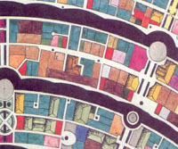
So if I’m designing the map of a fantasy city, it’s important not to spend all my time looking at other people’s maps of fantasy cities. Coming into the project I already brought a weird and eclectic mix of knowledge –ranging from the study of medieval cities to classes in urban planning.

And I’m also lucky to be living in this day and age, because Google Earth makes it almost trivial to snag satellite imagery detailing the layout of streets and the shape of real buildings. So, as part of my prep work, I spent a couple of hours grabbing evocative and visually interesting satellite photos from a variety of cities:

Rome - Satellite View

Rome

Rome - Satellite View

Moscow

Rome - Satellite View

London

Rome - Satellite View

Kyoto

Because Anyoc was built entirely on one large hill, it was particularly important for me to be able to look at how streets and hills historically interacted (before the modern era when streets tend to simply cleave through the local geography). What I discovered that roads will generally follow the curve of the land, but not always precisely and often with exceptions. (It may be difficult to climb straight up that steep hill, but sometimes it may be easier than the alternatives.)

This was a good lesson to learn, because before studying these real world cities I had an inclination towards making the roads follow the geography almost religiously. I’m glad I moved away from that, because the result looked very unnatural — resembling something closer to the contour map instead of a city.

When I was done, I (literally) had my road map:

Anyoc Streets

Continued…

The Map of Anyoc

October 22nd, 2008

City Supplement 3: Anyoc was essentially a completed product when Dream Machine Productions went on hiatus. The only thing we were waiting for was the map. In fact, it was my intention to release it as our last product before the hiatus. But, unfortunately, the cartographer we had working on the project never completed it. Since we were shifting into a hiatus state in any case, I shelved the project.

As we started gearing up to come out of hiatus, however, I started working on the map myself. Here’s what the original sketch map that I drew way back in 2001 looked like:

Map of Anyoc - Original Sketch Map

Basically, there was little laid out except for the gross geography and spatial relationships of the city. However, I know that one of the things I love about a good city supplement is the map: As a handout, there are few things more satisfying than being able to slap down a really slick-looking map for the players to look at. And I’ve found that there are few things that can get my creative juices flowing like a good map: Imagine yourself standing on those streets and looking at those buildings. What does that colorful roof really look like? What lies beyond that door or hidden around that corner?

I knew that executing a city map to the standards that I would demand out of a product would be tough. I had previously designed the map for Aerie (City Supplement 2), but that was a very different type of project: Aerie had been carved out of solid rock according to a relatively rigid plan. For Anyoc, I felt it was important to capture the more natural and organic curves of a living city.

So I started researching.

SURVEYING THE FIELD

The first part of this research was a matter of “surveying the field”. I went to my shelves and pulled down a wide representative sampling of city maps from other roleplaying supplements. Notable examples include:

As you can see, there have been many different ways of handling the cartography for fantasy cities. Based on my recent experience with Ptolus, among other things, I knew how incredibly useful it could be to have every street and every building detailed on the map. As a player, I love the ability to say “I’m going to X by heading down this street right here”. And as a DM I love being able to say, “Okay, the House of Violet Gold is this building right here.”

With those goals in mind, I pushed aside the very generic style of maps like the one seen in the Freeport sample above. These types of maps are a bit more graphically detailed than my sketch on graph paper, but the detail is largely illusory — none of those blobs actually represent anything meaningfully concrete.

I also stepped away from the style of map seen in the Minas Tirith sample above: These maps resemble the kind of cartographical lot maps created by city surveyors and the like.

While I couldn’t create the type of detailed, individual buildings created by Ed Bourelle for Ptolus (unless I wanted to charge a lot more for the finished product than I was planning to), I felt that a “roof outline” style (such as those used in the Raven’s Bluff and Sharn examples above) represented the best compromise. Here’s the style I ended up with:

Map of Anyoc - Sample Style

With a style in hand, it was time to start laying out the streets. But before I could do that, I had to finish my research.

Continued…

City Supplement 3: Anyoc

October 20th, 2008

City Supplement 3: Anyoc

WALLS OF FAIRY STONE AND BLOOD…

Built of the seven fairy stones, the city of Anyoc stands proudly upon its hill. Pale purples mix with soft blues and faded greens; pinkish reds stand in contrast to burnished gold. And its white walls of essabas – the star stone – gleam in the bright light of the sun.

But long ago, in days dimmed by the thick mists of time, the site where Anyoc now stands was home to another great city: A black city which served dark and evil powers. It was said that the walls of that nameless city towered above its streets to a height of five hundred feet, and every inch of them was stained black with blood.

And beneath the streets of Anyoc, that ancient evil still waits for the time of its return…

City Supplement 3: Anyoc features full-color, black-and-white, and poster-size (21″ x 16″) maps of the city, a complete gazetteer featuring more than 30 unique locations, and bonus maps of the Westgate military complex and the Street of Trade!

Full-color maps only available in the Deluxe Color and PDF editions.

Each City Supplement provides a complete fantasy city. In addition to a full-page map of the city, each supplement includes a description of the city’s full history, an overview of the major characters and organizations, adventure seeds, and a complete gazetteer.

B&W Print EditionDeluxe Color Edition
RPGNow PDFLulu PDF – Paizo PDF
36 pages – Sample City Map

Anyoc Sample Map

Aerie – Mini-Web Supplement

September 5th, 2008

City Supplement 2: AerieAtop the peak of Mt. Auroch, the fabled griffon riders make their home in the city of Aerie…

I was recently going through my original notes for City Supplement 2: Aerie and discovered a rather nifty idea that had gotten misplaced and left out of the final product. So I thought I’d showcase it here for anyone who might be interested…

THE SPRING THAW

The city of Aerie is carved into the very mountain itself. The tier of the Lower City is dwarfed upon the western side by the Griffon Wall and upon the other by the Upper City, which rises 300 feet. And above the Upper city, seeming to stand sentinel over the city below, is the Fort on the Mount, home to the fabled Griffon Knights.

And towering above it all is the snowy peak of Mt. Auroch.

Each spring, the mountain snow above the city begins to thaw, creating a considerable amount of run-off. The city would be regularly flooded if it were not for the extensive drainage system which carries water from along the eastern wall, under the Uppe rCity, and down to the river in the Lower City. This run-off does raise the level of the river considerably, and the River Road is often flooded during this time of the year — but it was designed specifically to handle the overflow.

A secondary effect of the spring thaw, however, are the beautiful waterfalls which form along the eastern wall during the greater periods of run-off. Fifty years ago, the eastern portion of the Upper City actually suffered from an avalanche as snow plummeted off the wall and buried dozens of buildings.

Buy PDFPrint Edition

Aerie Poster Map

July 8th, 2007

I have been suffering from a really miserable case of the flu ever since the evening of the 4th. I drove down to Rochester to spend the holiday with my father, and by the time I got there the back of my throat was a raging inferno of pain. I probably should have been smart about it and headed straight to bed, but I decided to tough it out and went to see the fireworks. (Which were fabulous, as is Rochester’s wont. Apparently the same gentlemen, Jim Freeman, has been doing them for 58 years. And he does a marvelous job of it, understanding that there is more to an effective fireworks show than simply churning out explosive as fast as you can.)

The penalty for my extravagance was, unfortunately, spending most of Thursday in a near-delirium. I’m finally feeling better today, but I’m still not at 100%.

Aerie - Poster MapDespite that, I’ve got some more news from Dream Machine Productions: Due to Lulu’s recent expansion into art prints, we can offer a poster map for City Supplement 2: Aerie. It’s available in both a keyed and non-keyed format.

At a deluxe size, with dimensions of 36″ x 24″, this map is the perfect companion piece for using the city of Aerie in your campaign, with individual buildings and streets easily distinguishable.

It is our expectation that all future city supplements will be accompanied by poster-size maps. Unfortunately, a poster-size map will not be released for City Supplement 1: Dweredell, as the map for Dweredell was not executed at a resolution to make that possible.

And, as some people have asked me about this: This does not mean that the supplements themselves will not include maps.

Archives

Recent Posts


Recent Comments

Copyright © The Alexandrian. All rights reserved.