Pointcrawls are a pretty straightforward scenario structure: You create a map with locations which are connected with paths, forming a node map. If you want to get more clinical in your descriptions, you can also refer to the locations as points (hence the first half of the name) and the paths as connectors. During play, PCs in a location can choose one of the paths connected to that location and travel along it to another location. They can thus crawl (there’s the other half of the name) through the pointmap.
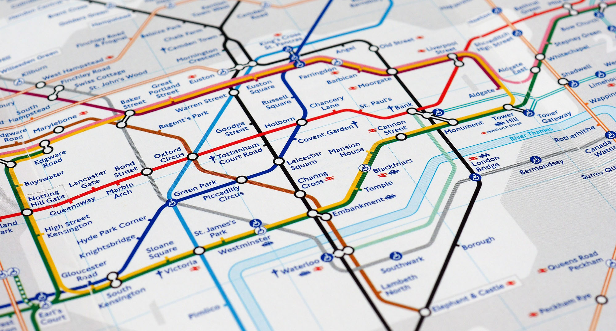
The concept of the pointcrawl was first formalized by Chris Kutalik on his Hill Cantons blog in 2014, although antecedents can be found. For example, Dragons of Hope, the third Dragonlance Chronicles module, features a proto-pointcrawl of linked regions. Even the famous, multicolored tube map of the London Underground first designed by Harry Beck (and seen above) displays similar properties.
THE MANY-HEADED POINT
What makes the pointcrawl so versatile as a scenario structure is that each “point” can be literally any point of interest. It might be extremely specific, like “that strange red rock outside of town.” Or it could be very large, like “the city of Warnock” or “the Kingdom of Catalac.” The structure can even be adapted to other milieus entirely, with points like “the VR server of Thunderdome, MLC.”
The structure is quite flexible, with points of different “scale” easily coexisting. (For example, “that strange red rock outside of town” and “the city of Warnock” could easily both appear on the same pointmap.) It can also be trivially fractal, with the point on one pointmap being an entirely self-contained pointcrawl in its own right.
LITERAL vs. ABSTRACT PATHS
A pointcrawl exists within a strata, and to truly understand, design, and run the pointcrawl, you need to have an understanding of that underlying reality. For example, the city of Warnock and our strange red rock aren’t just floating nebulously in a hypothetical node map: The red rock lies east of Warnock in the Forest of Arden. Or maybe it instead lies to the west on the far side of the Daggerpoint Mountains.
Understanding this will allow you to answer questions like:
- Which connections exist (and don’t exist) in the first place?
- How long does it take to travel from point to another?
- How should you describe the journey along the path?
And so forth.
The most literal application of a pointcrawl system is to model wilderness travel along a trail system (i.e., the connections between points are literally wilderness trails or roads running between those locations). These are examples of literal paths, and are almost always a player-known structure: The pointmap has a one-to-one correspondence with the game world, and the characters can see the trails or roads that they’re following.
But pointcrawls can also work with abstract paths, which seek to capture the conceptual navigation of an environment in a way that allows you to focus prep and structure play. An example of this is an urban pointcrawl, where a pointcrawl would not for example, include every single street and building in the city. Instead, the connections of an urban pointcrawl represent the way we think about traveling through a city.
This can be a bit harder to get your hands around than literal paths, so how does it actually work?
When the players indicate a navigational intention, the GM basically acts as an “interpreter” who translates that intention into the pointcrawl system, uses the pointcrawl system to resolve it, and then describes the outcome to the players in terms of the fiction.
This works because we naturally think of navigating a city in broad terms. “We need to head west to Lyndale Avenue and then take that south into Edina.” What was the exact route we took to get to Lyndale? Did we take 36th or 38th or 42nd or 46th? We don’t really care. Particularly in a pre-GPS era, navigation was even more likely to funnel into landmarks and major thoroughfares: Cross the river at such-and-such bridge, head east to the cathedral, and then cut south through Littlehut… and so forth.
The points of the pointcrawl match the mental model we use to navigate through a city.
For example, consider this map of the hellish city of Elturel from the Alexandrian Remix of Descent Into Avernus:
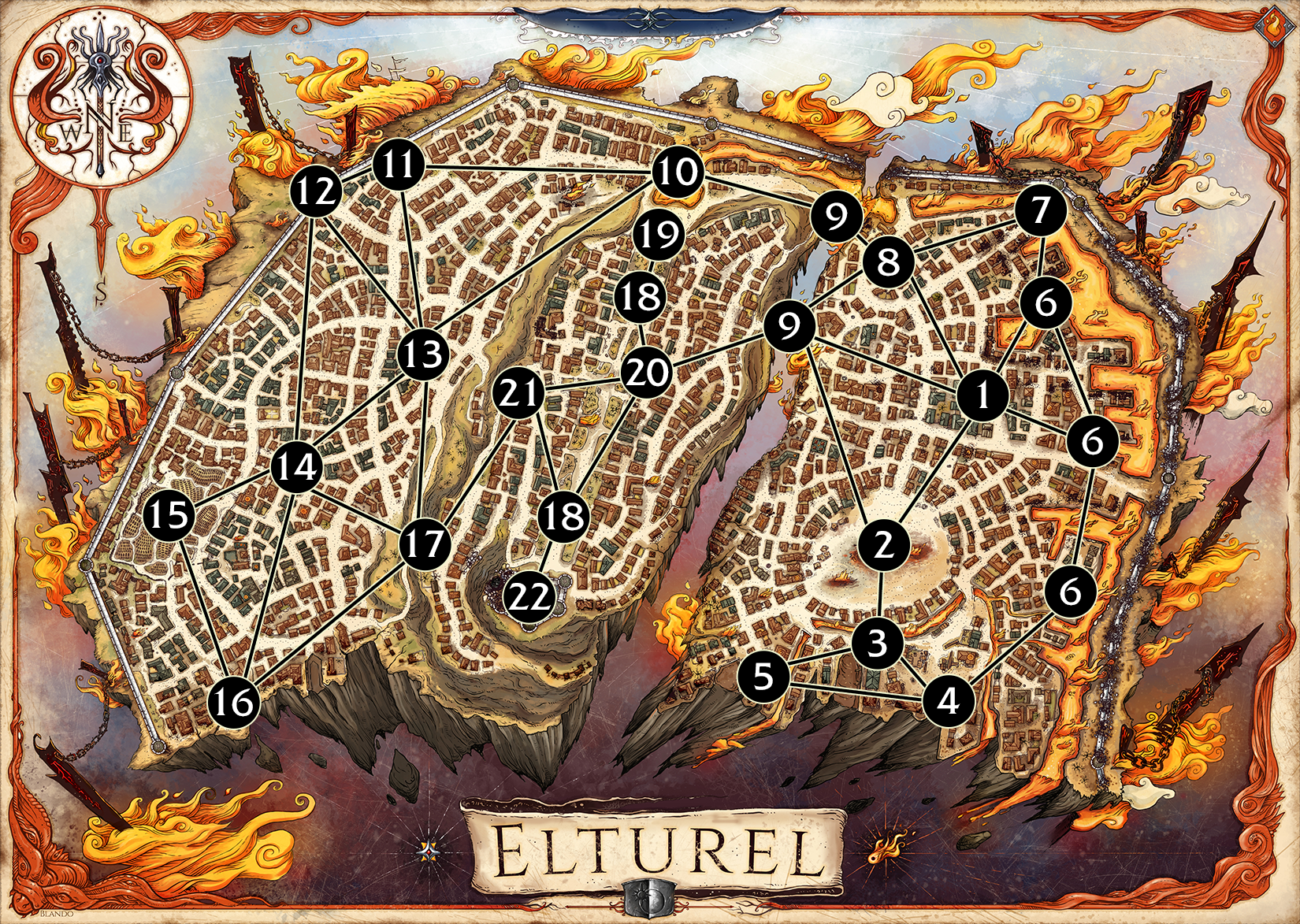
You can see how this navigation works most clearly at Torm’s Bridges (Area 9). Here the conceptual and literal geographical navigation of the city are basically unified; the funnel effect is as literal as possible: If you want to cross the gorge between the western and eastern halves of the city, you’re going to have to cross those bridges.
But this conceptually remains true even when the literal geographical funnel is not so precise: If the PCs decide to head south Area 1, for example, they’re going to pass through Shiarra’s Market (Area 2). Yes, it’s technically possible to take a different route that narrowly avoids the market, but in the absence of intentionality the point-map represents the general “flow” of the city.
You can also see from this example how literal and abstract paths can coexist in the same pointmap: Torm’s Bridges are quite literal; “you’ll pass through Shiarra’s Market on your way to the Docks” is more abstract. The same thing could hold true in our hypothetical wilderness pointcrawl from before (“you can follow all these literal roads, but if you try to cut through the Forest of Arden you’ll bump into the weird red rock”).
So you can really think of this as more of a spectrum options than a hard choice.
EXPLORATION vs. ROUTE-PLANNING
Another finesse to consider here is whether the PCs are exploring the pointmap (i.e., they don’t know what points are available and/or what paths they can take until they discover them) or if they have some sort of map or comparable knowledge which allows them to plan their journeys.
This may or may not be related to whether or not the pointcrawl is a player-known structure. (For example, the PCs might have a diegetic map of Elturel even if the players don’t know that the GM is using a pointcrawl.) Hybrid approaches are also quite common, with some routes or points being known while others remain secrets to be discovered. And, of course, an exploration model will naturally turn into route-planning as the PCs make their discoveries and create their own maps.
THINGS YOU’RE LIKELY TO SAY
Things you’re likely to say while running a pointcrawl include:
- “Crossing Waterloo Bridge, you head south past the London Eye to Lambeth Palace.” (The PCs are leaving a vampire den somewhere near Covent Garden. Waterloo Bridge, the London Eye, and Lambeth Palace are all locations on the pointmap. In this case, the players already have some familiarity — or perhaps a great deal of familiarity — with the city, recognizing these locations without the GM needing to elaborately describe them.
- “Following the bonsai turtles, you pass through an arch in the hedgerow and find yourselves standing at the top of an ancient amphitheater. Benches of worn stone descend to a circular area where three of the bonsai turtles have already gathered. On the far side of the amphitheater you can see two other arches like the one you’ve just come through, leading to other paths through the Maze.” (The amphitheater is a location the PCs have just discovered. The GM is indicating the existence of two other paths, leading to other locations, that the PCs could follow.)
- “You’ve been following the deer path for a couple of hours when Lavid hears the distinctive hooting call of the local goblin tribe. It sounds like they’re coming down the path from the opposite direction.” (The PCs are currently traveling along a connection and a random encounter has been triggered.)
- “You take Nephranter’s Street through the Court of the White Bull and then south to the Caravan Court.” (The nodes here are the Court of the White Bull and Caravan Court. “Nephranter Street” is a way of contextualizing the journey; it’s pulled from the strata of the Waterdeep city map to describe the abstract path. The GM could just as easily say “…passing through the bustling crowds of River Street before reaching Caravan Court” or simply “…you cross the Trade Ward to Caravan Court.”)
- “You’ve reached the weird red rock. Do you want to head north towards the Trollfens or south towards the Black Bog?” (The weird red rock, Trollfens, and Black Bog are obviously all points which the PCs are familiar with.)
Although the examples vary, in each case the basic structure of connection-point-connection-point becomes a comfortable framework for the GM to describe the journey, and for the players to understand it and make choices during it.
BASIC POINTCRAWL PROCEDURES
The basic procedures for a pointcrawl are very simple.
STEP 1 – FOLLOW A PATH. The PCs choose one of the paths connected to their current point and follow it.
Time: The length of time it takes to follow a path may be standardized for an entire pointcrawl. (For example, you may assume it always takes 10-15 minutes to move from point to another in an urban setting.) Alternatively, different connections may take different amounts of time. If so, this can be indicated directly on the map using either small numbers or dots (with each dot representing one standard interval of time). In setting these times, you’ll most likely be taking the strata of the pointcrawl into account (e.g., traveling one mile down an open road will take less time than traveling ten miles through the tangled bracken of a wild forest).
STEP 2 – RANDOM ENCOUNTER. Check for a random encounter.
Procedure: Any number of random encounter procedures could be employed here. I discuss these options in more detail in Part 5 of the 5E Hexcrawls series. If you are using standard time intervals for your connections, you might consider making one check per interval.
STEP 3 – ARRIVAL. The PCs arrive at the next point.
If the PCs are in a point on the pointmap, you can simply follow this procedure. If for some reason they’ve slipped “off” the pointmap, simply funnel them logically into the pointmap and continue from there. (You might be able to assume they’re “at” the nearest point on the map; e.g., they may not be at the cathedral, but they’re close enough that they’re basically “coming from the cathedral” as far as other points are concerned. Alternatively, if you want to get all formal with it, you can think of their current location as a “temporary point” and think about how it would attach to the pointmap.)


I think some words are missing after “recognizing these locations without the GM needing to” – possibly something as simple as “describe them,” but still.
I’m curious what you’d say are the major advantages/disadvantages of using a point crawl instead of a hex crawl? I could see it being more flexible, but in an exploration based game (as some of your examples) what would push you to one or the other? Or a depth crawl for that matter?
It seems like a point crawl would naturally evolve out of a hex crawl, as a kind of shorthand or fast travel, at least to already discovered lands. You finished the dungeon delve and decide to head back to town because the session is almost over. Fast travel back. It’s now a point crawl. If you combined both, the hex crawl exists to find new points and show how they exist in a space relative to old points, and show how they are connected, after which the point crawl is used.
I mean, the whole thing is the scenario structure of Zork (or any of the old text adventures starting from ADVENT through modern Interactive Fiction).“Rooms” linked by “connections” which the player explores by commanding their avatar to interact with the world.
Funny enough I’m doing something you’ve covered (Urbancrawl) and after suggestion by someone else, I found this article & I’ll be intergrating this pointcrawl as a session 0. How this will work for me: Selecting a hex near the center point of the urban crawl map and then make a path toward one of the exterior city gates and usign that as the pointcrawl’s basis.