Travel times in Icewind Dale: Rime of the Frostmaiden are somewhat confusing and difficult to reference. Due to the harsh winter conditions of the Dale, the normal rules for overland travel in 5th Edition don’t apply. Instead:
The speed that characters can travel across Icewind Dale’s rough, snowy terrain is given in the Overland Travel table. Travel is less time-consuming on the snowy roads and trails that connect the settlements of Ten-Towns, as discussed in Chapter 1.
| Method of Travel | Distance per Hour |
|---|---|
| Dogsled | 1 mile |
| On foot, with snowshoes | 1/2 mile |
| On foot, without snowshoes | 1/4 mile |
If you look up the equipment entry for dogsleds, there’s also this rule:
Sled dogs must take a short rest after pulling a sled for 1 hour; otherwise, they gain one level of exhaustion.
It’s unclear whether this rule is already calculated into the distance per hour for dogsleds given on the Method of Travel table.
The guidelines for road/trail travel in Chapter 1 are not generalized, but are instead presented in sections like this one (for the town of Bremen):
Heavy snow has obliterated the trail that once guided travelers to Targos. Adventurers determined to make the journey on foot can reach Targos in 2 hours. Using mounts or dogsleds can reduce this travel time by as much as 50 percent.
No specific speed for road travel is given, but if you run the numbers they tend to land somewhere between 1.25 and 2.25 miles per hour.
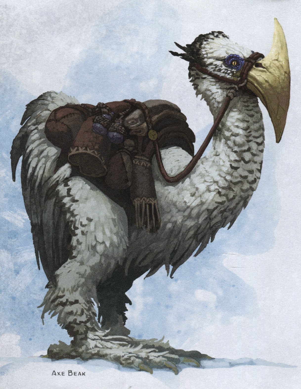
The book also includes incredibly awesome axe beak mounts… but neglects to give a speed for them.
RECOMMENDED TRAVEL RULES
| Method of Travel | Mountains (Distance per Hour) | Tundra (Distance per Hour) | Road (Distance per Hour) |
|---|---|---|---|
| Dogsled | 1/2 mile | 1 mile | 4 miles |
| Axe Beak | 1/2 mile | 1 mile | 2 miles |
| On foot, with snowshoes | 1/4 mile | 1/2 mile | 2 miles |
| On foot, without snowshoes | 1/8 mile | 1/4 mile | 2 miles |
Dogsleds: These rules assume that dogsleds increase their speed in the same ratio as humans do on the roads. These travel times include 1 hour of rest for every hour of travel. Double the speed if the dogs are not being given rest, but they suffer 1 level of exhaustion per hour (which means after the second hour of being pushed their speed will be halved).
Axe Beaks: I’ve arbitrarily decided they move very well through snow or across trackless tundra, but perform like a normal mount on roads (traveling at the same speed as a humanoid). On roads, this means axe beak mounts can gallop at 6 miles per hour, but at the cost of suffering 2 levels of exhaustion per hour. (This means that after the first hour of a gallop, their speed will be halved.)
On Foot: Snowshoes don’t help on roads.
OPTIONAL: TRAVEL PACE
In modifying the rules for overland travel, Icewind Dale: Rime of the Frostmaiden doesn’t specify how travel pace should be handled. If you assume the table above lists a Normal pace of travel, you can use the table below to calculate Fast and Slow paces.
Fast Pace: -5 penalty to passive Wisdom (Perception) scores
Slow Pace: Able to use Stealth
| Slow Pace | Normal Pace | Fast Pace |
|---|---|---|
| 1/8 mile | 1/4 mile | 1/2 mile |
| 1/4 mile | 1/2 mile | 1 mile |
| 1/2 mile | 1 mile | 1 1/2 miles |
| 1 mile | 2 miles | 3 miles |
| 2 miles | 4 miles | 6 miles |
Design Note: The comparison between dogsleds under snowy conditions and horses under normal conditions gets wonky. This is because Icewind Dale reduces human speed by two-thirds, but then has dogsleds moving at twice that speed. The net result is that you end up with dogs in snow being faster than horses on open ground. However, my research indicates these values are broadly accurate for how dogsleds perform in the real world, so I’m going to let the book values stand.
OPTIONAL RULE: DETERIORATING ROADS
Although the roads between the settlements of Ten-Towns are still kept open and trade is mostly uninterrupted, the Frostmaiden’s eternal winter has pushed the region’s infrastructure to the breaking point. Drifting snow and frequent blizzards can effectively obliterate the road between two towns.
There is a 1 in 6 chance of encountering an obliterated road (check for each section of the road).
It is still possible to follow the track of an obliterated road (due to tall waymarker posts that still manage to rise above the ever-growing snowpack), but characters on an obliterated road cannot travel faster than Slow Pace. Furthermore, the group’s navigator must make a DC 12 Wisdom (Survival) check each hour or veer off the road.
If the check fails, the party wanders off course and gets no closer to their destination in that hour. It takes an additional check to find the road again, with each failure costing the group an additional hour.
REFERENCE TOOLS
I also thought it would be useful to compile the travel data into some easy-to-use references, which you’ll find below.
MAP: TRAVEL TIME
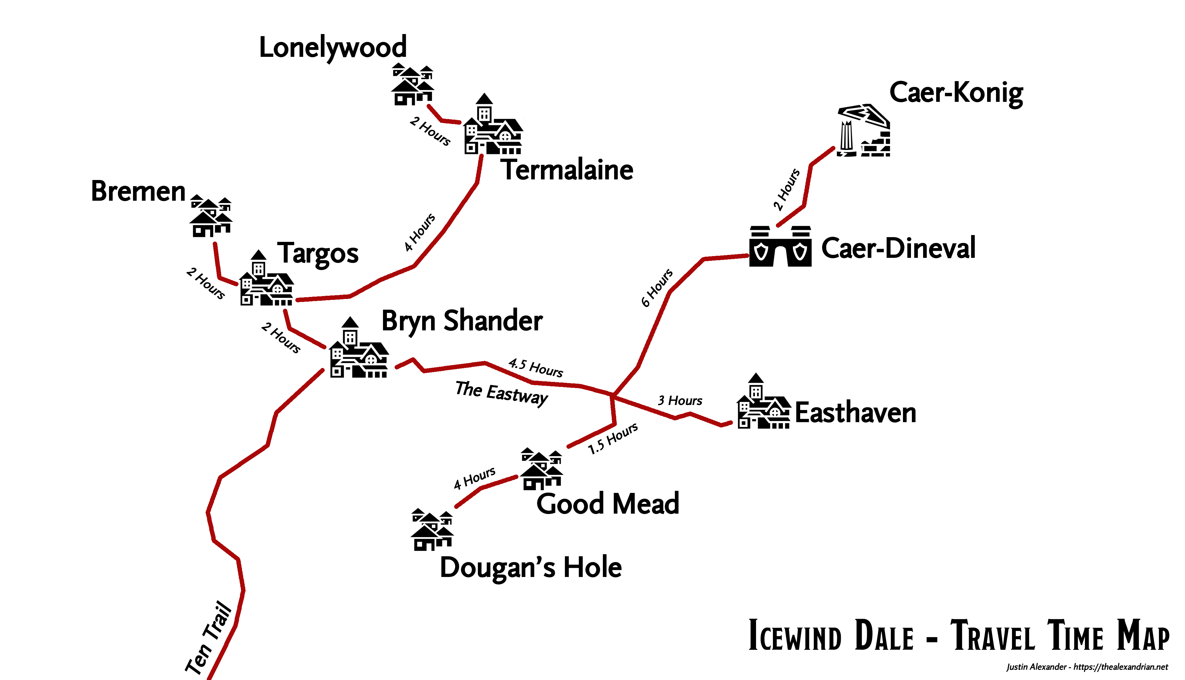
This map compiles the travel times given in each town’s entry in the Rime of the Frostmaiden. It turns out, however, that these values are inconsistent with each other along the Eastway. They’ve been adjusted for consistency here (which, of course, means that some of these values will be slightly out of sync with the book).
Note: The path between Bremen and Targos has been “obliterated,” which appears to roughly double what would otherwise be the travel time between these towns. If you’re using the optional rules for deteriorating roads, you’ll want to take this into account.
MAP: TRAVEL DISTANCE
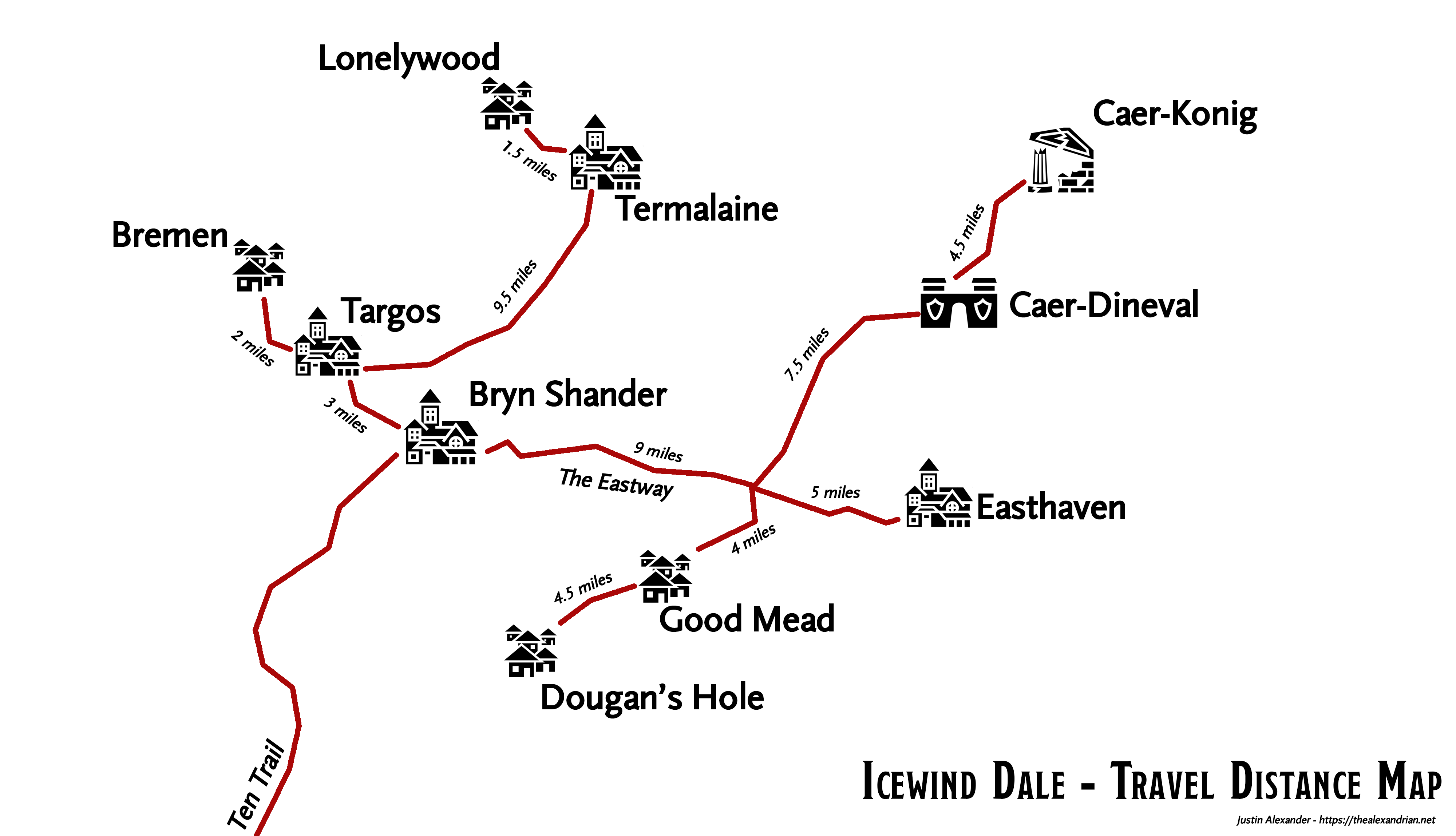
This map lists the distance in miles between each settlement. These distances are calculated directly from the poster map that comes with the book, using the included scale and following the precise path of the trail/road indicated.
(Technically I used the D&D Beyond version of the map, and then used Adobe Illustrator to trace each path and then precisely calculate its length.)
If you calculate the travel times from the distances given here, you will not end up with the travel times given Travel Time Map. This is because the travel times given in the book are all radically inconsistent: Routes are referred to indiscriminately as roads, trails, or paths. Some routes are referred to as being blocked or obliterated. But none of these descriptions have any relation, as far as I can tell, to the variances in travel time given.
ICEWIND DALE TRAVEL SPREADSHEET
You can download an Excel spreadsheet with Icewind Dale travel information here. It contains the following sheets:
- Rounded Distance: As noted above, I calculated precise distances from the original map. This sheet rounds those distances to the nearest half mile.
- Travel Time (Foot): This sheet has the travel time in hours between all ten towns. These values are calculated using the values on the Rounded Distance sheet and the recommended travel rules above (not the time values given in the book).
- Travel Time (Dogsled): Same thing, but for dogsleds.
- Travel Time (Dogsled – No Rest): Same thing, but this assumes the party is pushing their mush team to the limits without any rest. These values have been manually adjusted where necessary to reflect that the speed of the dogs’ becomes halved after two hours due to exhaustion. Some journeys will kill the dogs if they are not allowed to rest, and this is also indicated.
- Raw Distance Data: This is the original, raw distance data as directly measured from the original map. It’s included mainly as a curiosity here.
All of these tables include an entry for “Intersection,” which is the intersection between the Eastway and the north-south road running from Dougan’s Hole to Caer-Konig.


Per the book, mounts (axebeaks) and dogsleds move at roughly the same speed between towns. If you look at the entries describing how fast travel is between towns it states that mounts are roughly twice as fast on foot travel.
Also, traveling at a fast pace in the DMG is only 1.33 times the speed of a normal pace. The multiplier for a slow pace is 0.66.
I would assume that the overland travel times already factor in the rest for sled dogs, otherwise dogsleds would be no faster than trudging through the snow in snowshoes.
My understanding from interviews and the book is that the axebeaks are intended to move at roughly the same rate as dogsleds, just with reduced carrying capacity.
Jacob wrote: Per the book, mounts (axebeaks) and dogsleds move at roughly the same speed between towns. If you look at the entries describing how fast travel is between towns it states that mounts are roughly twice as fast on foot travel.
So the problem here is that there’s a more-or-less throw-away line repeated in most city entries that appears to assert mounts move faster than humans on roads; e.g. “Using mounts and dogsleds can reduce this travel time by as much as 50 percent.”
The problem is that this isn’t how mounts work in 5th Edition: Mounts have the same overland travel speeds as humanoids, but can “gallop for about an hour, covering twice the usual distance for a fast pace.”
Technically, however, these statements are not in conflict: Using mounts CAN reduce travel time because the distance between most towns in Ten-Towns is small enough that moving at twice the speed of Fast Pace for an hour can substantially reduce your travel time.
This is represented in the rules for axe beak mounts given in the post.
Now, what about dogsleds? Should they just be treated like mounts? That would be consistent with how mounts are handled in 5th Edition. But Rime of the Frostmaiden explicitly makes them special snowflakes. I decided to maintain that decision (and, as I noted, this is also more consistent with real world speeds for dogsleds).
Jacob wrote: Also, traveling at a fast pace in the DMG is only 1.33 times the speed of a normal pace. The multiplier for a slow pace is 0.66.
Anyone interested in calculating travel distances in 33/200ths of a mile instead of 25/200ths (1/8th) of a mile is welcome to do so. 😉
Representing the lakes on this map would be useful for representing why you can’t cut from Caer-Dineval to Termaline, as an example.
Frankly, the rules for long distance travel times in the PHB/DMG for faster-than-human creatures are nonsense. Galloping at 6 mph!? Flying at 12 mph!?
Horses trot at about 8 mph. Birds general fly around 40-100 mph and can fly several hundred miles in just one day.
As you point out, the travel speeds for dogsleds in RotF are more realistic. RotF also states that mounts and sleds move at about the same speed. Why would anyone want to re-engineer the lousy rules from the PHB/DMG to apply to our beautiful axebeaks?
Why would I even want to calculate distances in 25/200ths of a mile? That seems like overkill. Just calculate how long it will take you at a normal pace, then add half that for a slow pace or subtract a quarter for a fast pace.
e.g. RotF says it takes 2 hours to hike from Targos to Bremen (even with half of the road obliterated by snow, I’d probably rule it takes 3 hours without snowshoes). That’s 1.5 hours at a fast pace, and 3 hours at a slow pace. With mounts or sleds we halve that, 1 hour at a normal pace, 45 min at a fast pace, and 1.5 hours at a slow pace. Easy-peasey.
With you previously discussing how important the Survival skill is, does the module utilize the harsh snowy environment and travel times as more than set dressing? If not, I’d be interested in how you’d translate this into creating or enhancing scenarios.
I’m thinking of drawing out a nice hand-drawn map of the area with your distances and times on to provide to my players as a handout. I want to ask before I do that though – have you considered these travel times against how they relate to the events of chapter 4?
There’s an extent to which none of this matters *too* much – until chapter 4 where suddenly the PCs care an awful lot about every single number on this map.
Basically, with V. showing up with dogsleds, you need to make some survival mountaineering checks. If your character’s pass it’s going to take at 12 hours to make it back to Easthaven. You have no chance of making it in time to save Dougan’s Hole or Good Mead.
That’s assuming V.’s dogs are all rested and she preplanned eveything expecting the attack.
I hadn’t thought to figure that the resting mechanic was figured into the dogsled travel numbers that makes more sense.
It’s great that they actually thought about travel times in this book, but they missed so many things. Like what happens when the party Druid decides to become a caribou and pull a cart? I feel like they could have defined the terrain and let us figured out the numbers specific to the party, instead of give us numbers that seems to not reflect a party at all…
Thanks for the hour travel map. I opened in a paint editor and added the overland and mountain travel times. This will be a hand out to my group.
Nice optional choices for traveling. I’ll just remark that axe beaks do have a speed of 50 feet, as outlined in the Monster Manual. Cheers!
@Erik: Sadly, 5th Edition contains no rules or guidelines for calculating overland travel speeds from tactical speeds.
I question whether factoring rest periods into the rate of travel for dogsleds was the best idea. It simplifies calculations if you’re making a journey of several days, but for shorter trips I fear it could be misleading.
For instance, the 4.5 mile trip from Dougan’s Hole to Good Mead should take just over half an hour, with no need for a rest, but it’s listed as 1.1 hours in your spreadsheet. Likewise, traveling from Good Mead to Targos — a total distance of 16 miles by the road — could be managed in three hours rather than the four listed (one hour to travel 8 miles, an hour of rest, and another hour to complete the journey).
(Btw, there’s a typo in your maps: “Gold Mead” instead of “Good Mead”. Also, there’s an error in the spreadsheet calculations for the Good Mead row of the dogsled travel times — the distances are divided by 2 instead of 4.)
Great post (: The book makes travel times really confusing to calculate. A pointcrawl map for the entire Icewind Dale should’ve helped.
“No specific speed for road travel is given”
It’s implied in the Overland Travel section in Dougan’s Hole, Lonelywood and Caer Konig that it’s 1,5 miles/hour.
“It turns out, however, that these values are inconsistent with each other along the Eastway.”
Seems like Bremen-Targos too.
For the Eastway… If you call the distances from the intersection to the adjacents towns A, B, C, D. it’s possible to write, with the info the book provides, a system with 6 equations and 4 variables, with no possible solution. There are though, two solutions that solve 5 of the 6 equations.
A=4,5 B=6 C=3 D=1,5 (the one you used on the map)
and A=4.25 B=6.25 C=2.75 D=1.75
I take the first.
This is brilliant, thank you for putting this together!! I really appreciate your efforts here:)
[…] can use to establish goals. These changes here are slightly different than the ones presented on The Alexandrian website, but I wanted to link their article as it’s of tremendous use. Of note, this remix […]
That first table is really useful. I personally just use the distinction ‘on foot/dogsled’ and ‘road/tundra’. Anything more than that I find cumbersome. I’m already juggling so many things in my head as a DM, rolling for destroyed roads etc is too much.
The goal of establishing travel times for me was twofold:
1. Create a psychological barrier for fast traveling between the towns. It saves me a whole lot of preparation if I only need to prepare adjacent towns or have a rough idea of where the players are going.
2. Ensure the players can design a realistic plan for intercepting the dragon. A big change I made is that I gave the players 3 real life minutes to change the dragon’s flight path. It’s the ultimate trolley problem and test of their feelings towards the towns! Save as many people as possible? Save their friends? Kill their enemies? It also gives a chance to save more towns, as by the book only Targos and Bryn stood a chance. A nearly destroyed setting is not interesting, a partially destroyed setting determined by player choice is.